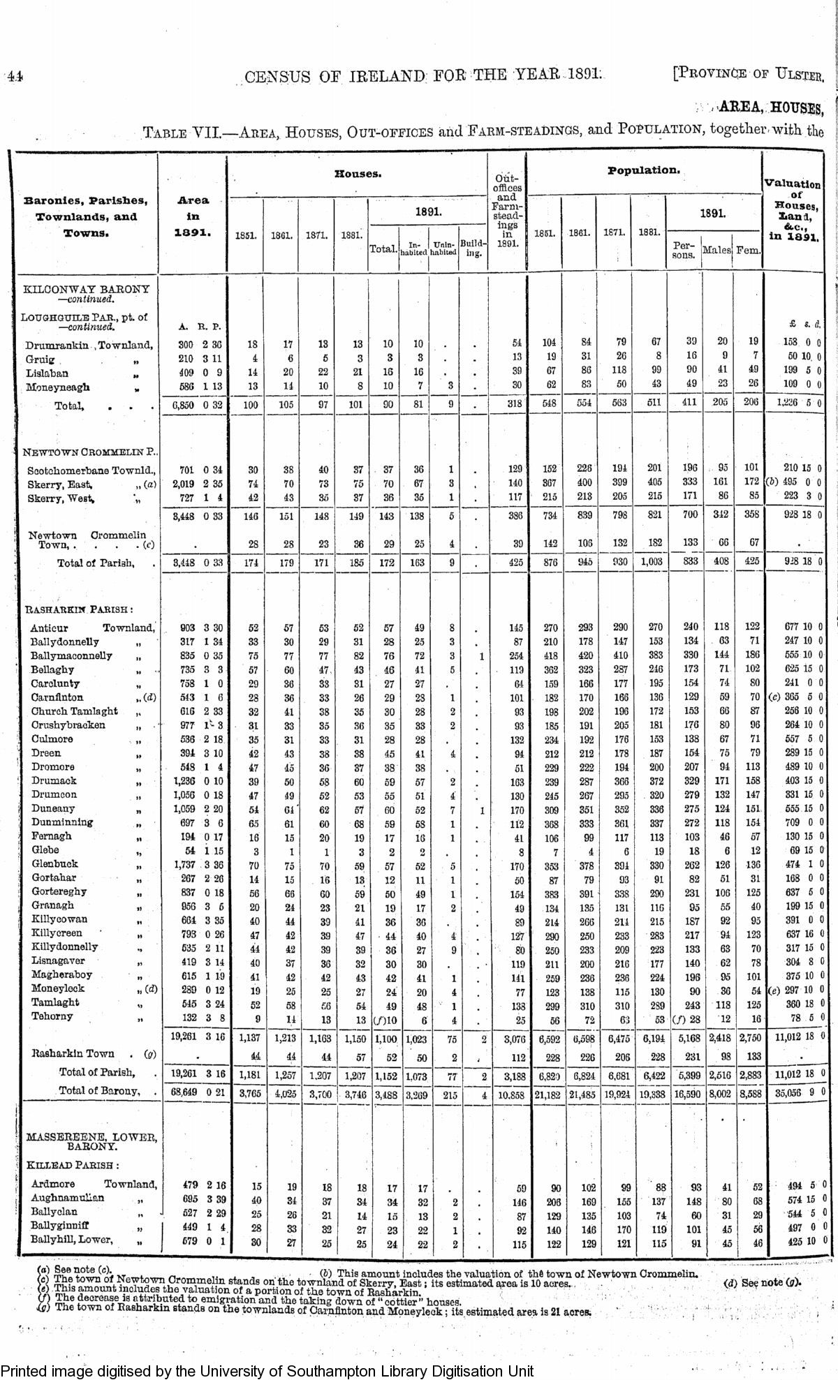
44.
CENSUS OF IRELAND FOR THE YEAR 1891.
[Province of Ulster.

i AREA, HOUSES, Table VII.—Area,
Houses, Out-offices and Farm-steadings, and Population, together with the 1

Area in 1891.

Houses.

Out-offices and Farm-stead-mgs in 1891.

Population.

Valuation

of Houses, liana, &e.,
in 1891,

Baronies, Parishes, Townlands, and

Towns.
1851.
1881.
1871.
1881.

1891.

1851.
1861.
1871.
1881.

1891.

Total.
In-1 Unin¬

habited lubited

Build¬ ing.
sPonrsJMales Fem-

1 1 KILOONWAY BARONY

—continued.
LOUGHGUIIxE PAR.,
pt.
of

—continued.
A.
R.
P.
£ s.
d Drumrankin .Townland,
300 2 36 18 17 13 13 10 10 54 104 84 79 67 39 20 19 158 0 0 Gruig „ 210 3 11 4 6 5 3 3 3 13 19 31 26 8 16 9 7 50 10 0 Lislaban „ 409 0 9 14 20 22 21 16 16 39 67 86 118 99 90 41 49 199 5 0 Moneyneagh „

Total,

586 1 13 13 14 10 8 10 7 3

—

30 318

62 83 50 43 49 23 26 109 0 0 6,850 0 32 100 105 97 101 90 81 9 548 554 563 511 411 205 206 1,236 5 0 i

• NEWTOWN CROMMELIN P.

Sootchomerbane Townld.,
701 0 34 30 38 40 37 37 36 1 .
129 152 228 194 201 196 95 101 210 15 0 Skerry, East, „ (a) 2,019 2 35 74 70 73 75 70 67 3

,

140 367 400 399 405 333 161 172 (b) 495 0 0 Skerry, West* "„ 727 1 4 42 43 35 37 36 35 1 117 215 213 205 215 171 86 85 223 3 0

3,448 0 33 146 151 148 149 143 138 5 386 734 839 798 821 700 312 358 928 18 0

' Newtown Crommelin

Town, ....
(c)

Total of Parish,

28 28 23 36 29 25 4 39 142 106 132 182 133

833

66 67 3,448 0 33 174 179 171 185 172 163 9 425 876 94o 930 1,003 408 425 928 18 0

Rasharkin Parish :

Antieur Townland, 903 3 30 52 57 53 52 57 49 8 145 270 293 290 270 240 118 122 677 10 0 Ballydonnelly „ 317 1 34 33 30 29 31 28 25 3 87 210 178 147 153 134 63 71 247 10 0 Ballymaconnelly „ 835 0 35 75 77 77 82 76 72 3 1 254 418 420 410 383 330 144 186 555 10 0 Bellaghy „ 735 3 3 57 60 47 43 46 41 5 119 362 323 287 246 173 71 102 625 15 0 Carelunty „ 758 1 0 29 36 33 31 27 27 61 159 166 177 195 154 74 SO 241 0 0 Carnflnton „ (d) 543 1 6 28 36 33 26 29 23 1 101 182 170 166 136 129 59 70 (e) 365 5 0 Church Tamlaght „ 616 2 33 32 41 38 35 30 28 2 93 198 202 196 172 153 66 87 256 10 0 Crushybracken „ 977 1-3 31 33 35 36 35 33 2 93 185 191 205 181 176 80 96 264 10 0 Culmore „ 536 2 18 35 31 33 31 28 28 132 234 192 176 153 138 67 71 557 5 0 ' Dreen

„ 394 3 10 42 43 38 38 45 41 4 94 212 212 178 187 154 75 79 289 15 0 Dromore „ 548 1 4 47 45 36 37 38 38 51 229 222 194 200 207 94 113 489 10 0 Drumack „ 1,236 0 10 39 50 58 60 59 57 2 163 239 287 366 372 329 171 158 403 15 0

> Drumcon „ 1,056 0 18 47 49 52 53 55 51 4 130 245 267 295 320 279 132 147 331 15 0 f Duneany „ 1,059 2 20 54 64' 62 57 60 52 7 1 170 309 351 352 336 275 124 151 555 15 0

i Dunmmning „ 697 3 6 65 61 60 68 59 58 1 112 368 333 361 337 272 118 154 709 0 0 / Fernagh „ 194 0 17 16 15 20 19 17 16 1 41 106 99 117 113 103 46 57 130 15 0

Glebe 54 1 15 3 1 1 3 2 o 8 7 4 6 19 18 6 12 69 15 0 Glenbuck „ 1,737 3 36 70 75 70 59 57 52 5 170 353 378 394 330 262 126 136 474 1 0 Gortahar „ 267 2 26 14 15 16 13 12 11 1 50 87 79 93 91 82 51 31 168 0 0 Gortereghy „ 837 0 18 56 66 60 59 50 49 1 154 383 391 338 290 231 106 125 637 5 0 Granagh „ 956 3 5 20 24 23 21 19 17 2 49 134 135 131 116 95 55 40 199 15 0 Killycowan „ 664 3 35 40 44 39 41 36 36 89 214 266 214 215 187 92 95 391 0 0 Killycreen „ Killydonnelly „ Lisnagaver „ Magheraboy „ Moneyleck „ (d) Tamlaght „ Tehorny „

793 0 26 635 2 11 419 3 14 615 1 19 289 0 12 545 3 24 132 3 8

47 44 40 41 19 52 9

42 42 37 42 25 58 14

39 39 36 42 25 £6 13

47 39 32 43 27 54 13

44 36 30 42 24 49 (/HO

40 27 30 41 20 48 6

4 9 1 4 1 4

127 80 119 141 77 138 25

290 250 211 259 123 299 56

250 233 200 236 138 310 72

233 209 216 236 115 310 61

283 223 177 224 130 289 53

217 133 140 196 90 243 (/)28

94 63 62 95 36 118 12

123 70 78 101 54 125 16

637 16 0 317 15 0 304 8 0 375 10 0 (e) 297 10 0

360 18 0 78 5 0 19,261 3 16 1,137 1,213 1,163 1,150 1,100 1,023 75 2 3,076 6,592 6,598 6,475 6,194 5,168 2,418 2,750 11,012 18 0 Rasharkin Town .
(g)

Total of Parish, Total of Barony, .

44 44 44 57 52 50 2 112 228 226 206 228 231 98 133 19,261 3 16 1,181 1,257 1,207 1,207 1,152 1073 77

—

2 3,188 6,82) 6,824 6,681 6,422

19,338

5,399 16,590

2,516 8,002

2,883 8,588

11,012 18 0 68,649 0 21 3,765 4,025 3,700 3,746 3,488 3,269 215 4 10.858
21,182 21,485 19,924 35,056 9 0

BARONY.

> killead Parish :

t

Ardmore Townland, f Aughnamullan „ Ballyclan „ Ballyginnifl „ Ballyhill, Lower, „

-

479 2 16 695 3 39 527 2 29 449 1 4 679 0 1

15 40 25 28 30

19 34 26 33 27

18 37 21 32 25

18 34 14 27 25

17 34 15 23 24

17 32 13 22 22

2 2 1 2

59 146 87 92 115

90 206 129 140 122

102 169 135 146 129

99 155 103 170 121

88 137 74 119 115

93 148 60 101 91

41 80 31 45 45

52 68 29 56 46

494 5 0 574 15 0 544 5 0 497 0 0 425 10 0 o) See note (c).
(b) This amount includes the valuation of the town of Newtown Crommelm.
,.1
Tlwtmira nf Wom^r n.«»n
xi .,
,

w -1-Uls amouuTi inciuues Tine valuation oi line rawn $ l^Sta&hSvf SVds onJhe toTnland of SkerrF, East; its estimated area is 10 acres.
?A
amount includes the valuation of a portion of the town of Rasharkin.
& ^^S^pSSl^*6?t0-,emiStion
and the takmg down of "cottier" houses.
is) The town of Rasharkin stands on the townlands of Carnflnton and Moneyleck; its estimated area is 21 acres.

{d) See note (a).